coast defense

Masthead Image

Boston Fire Control Structures (FCSs): Types and Numbers

In the modern (WW2) era, fire control for the coast artillery defending Boston Harbor involved a network of 46 fire control structures (FCSs). Each of these FCSs contained one or more so-called base end stations that were designed to observe and report on the movements of enemy ships. This network of FCSs extended for about 75 miles along the Massachusetts coast (and across the Harbor Islands), from Gurnet Point (on Plymouth Bay) in the south to Plum Island (near the New Hampshire border) in the north.

An inventory conducted by the author in 2010 identified 27 of these FCSs that had survived to the present. [A different network of FCSs existed in the pre-WW2 period, many of them built between 1900 and 1920. However, because most of these structures were cheaply built of wood and plaster (with tarpaper roofs), almost all of them have deteriorated and been razed over the past 100 years or so.]

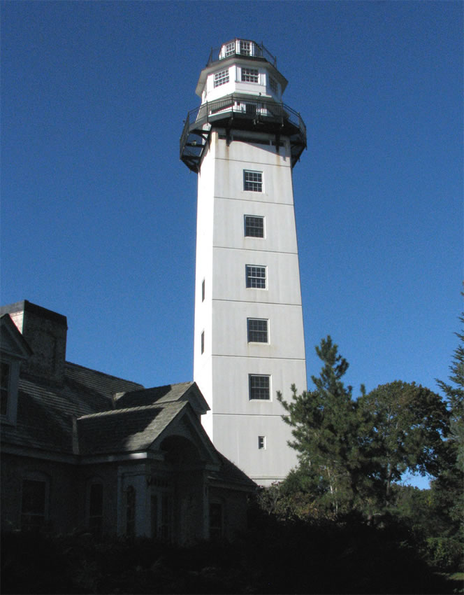
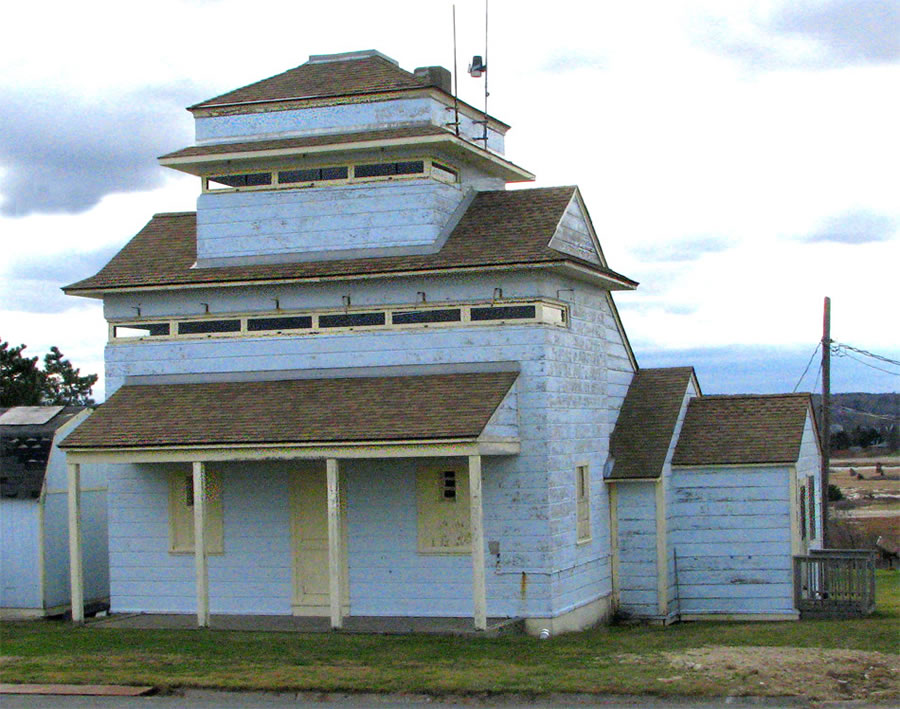
There are many different types of FCSs in the surviving WW2 era network. Two thirds (18) of the 27 "survivors" can be called fire control towers [see the Gallery at left, Slide 1]. These towers range in height from 2 to 10 stories. The tallest (neglecting the height of site) is the 10-story tower [Slide 2] at Gales Pt. in Manchester (which has recently been converted to 11 stories by enclosing its rooftop level). There are four 8-story towers: two at Nahant, one at Strawberry Point (Scituate), and one at Brant Rock (Marshfield). There is one 7-story tower (at Point Allerton), three 6-story, five 5-story, three with three stories, and one with two stories (the 1904 tower at Fort Andrews [Slide 3].

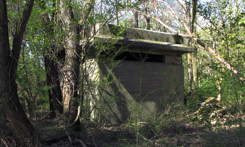
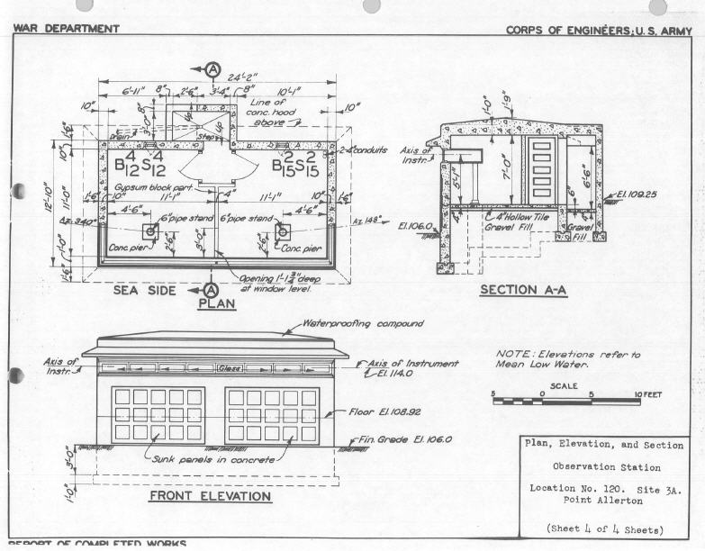
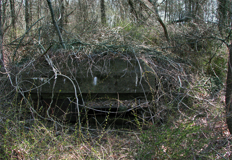
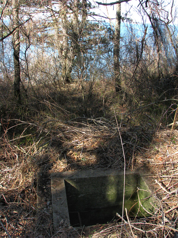
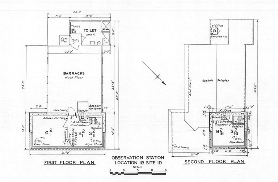
The rest of the surviving WW2-era FCSs, the shorter ones, are classified here as bunkers or cottages. What I call fire control bunkers were one- or two-level reinforced concrete structures, usually with footprints that were roughly 12 to14 ft. on a side. Some of these bunkers were built on the surface, like the west side bunker at Fort. Andrews [Slide 4] or the Site 3A "garage" bunker at Point Allerton [Slide 5]. Other bunkers were buried, like the CRF bunker at Fort Andrews [Slides 6 and 7], sometimes with only their vision slits and roofs showing above ground. Boston even has one "split level" bunker--a surface bunker with a second level protruding from its top [Slide 8]. And in some cases (e.g., at Fort Standish, or near Strawberry Hill in Hull) a concrete "bunker" was elevated above the ground on concrete pylons. The 6-inch gun batteries at Fourth Cliff and Outer Brewster Island featured concrete bunkers on top of the gun batteries themselves.

In describing FCSs, the Army did not use the term "bunker." The low-profile or buried FCSs were called "cottages" or "manholes." The term "cottage" is used on this website only to describe surface-built FCSs that actually looked like cottages, or low-profile surface-built buildings. I have found only one surviving bunker that I would call a "manhole"-- the Fort Andrews CRF bunker [Slides 6 and 7 again].

What I am calling a fire control cottage is typified by the structures on Strawberry Point in Scituate [one of which is detailed in Slides 9 through 11. Some of these cottages had a half-story "tower" or lookout extending from their single story. They usually had between one and 2.5 stories, and in one case (Site 2A at Point Allerton) had 3.5 stories.

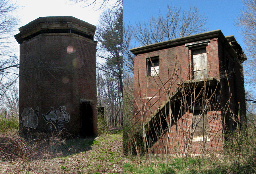
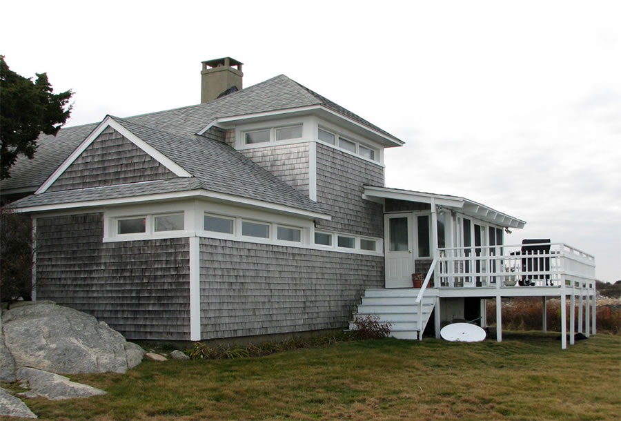
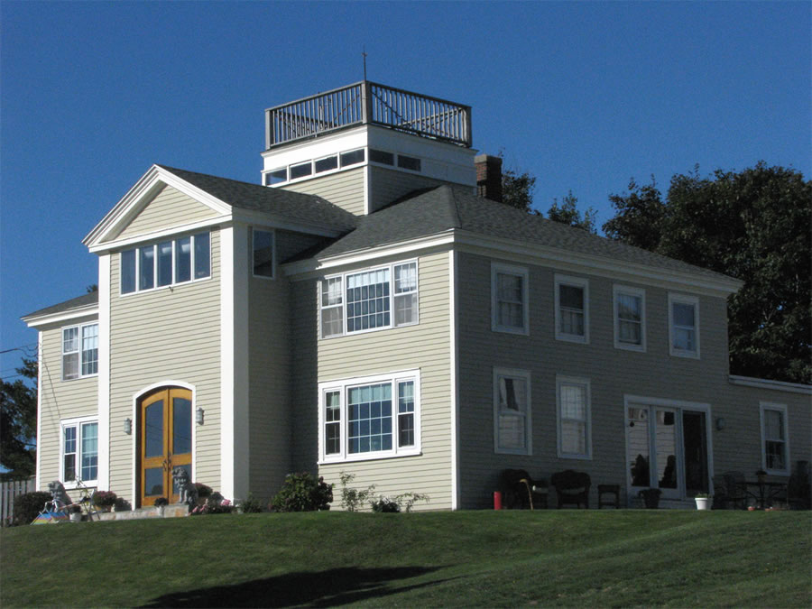
I have called the final type of FCS the "tower in a house." This type features a three-story concrete tower "built into" (and camouflaged to look like) a wooden frame house, often with wooden crew quarters and command offices attached to it. Examples of such towers exist at Fourth Cliff in Marshfield [Slide 13], on Marblehead Neck [Slide 12], and at Eastern Point in Gloucester.

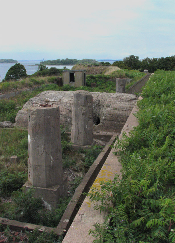
At the older harbor forts (viz,Standish, Strong and Warren) the only surviving parts of some pre-WW2 fire control structures are the concrete pylons that used to provide the mounting columns for the observing instruments, usually depression position finders (DPFs). These columns extended well under ground to provide a firm mounting point for the DPFs, and were built separate from their enclosing structures, which could be simple wood and plaster buildings with tarpaper roofs. Over time, these flimsy buildings collapsed, leaving behind the instrument pillars that can still be seen today [Slide 14].

Today, 12 of Boston's 27 surviving WW2-era FCSs (44%) are publicly owned. Most of these public sites are on the Boston Harbor Islands. Of the 15 structures that are privately owned, most (13) are towers, except for the two "cottages" at Strawberry Point in Hull. [Two pre-WW2 FSCs in Hull are also privately owned, one at Fort Revere and one at Strawberry Hill.] Of the 13 privately owned towers, the author has been inside six. At least three privately owned towers have been remodeled for all-season occupancy (with heat, lights, toilets, and kitchen facilities added), while the remaining 10 seem to be in largely original condition (with a few renovations to windows, roof access, and front doors). The unimproved privately owned towers that the author has visited have been stripped of almost all their internal fittings. Some of the fire control sites were leased by the government and returned to the original owners after WW2. Most often, these sites had been purchased by the govenment and were then declared surplus and sold off during the period 1946-1955 .

The federal government still owns two FCSs--the tower and cottage at Fourth Cliff in Marshfield. This site, which also features many surviving parts of Battery 208 (a WW2 battery with two 6-inch guns), is now used by the US Air Force as a recreation site for military personnel.

With a few exceptions, the surviving FCSs are not easily visitable by the public. [NOTE: The 5-story tower at Halibut Point is now a state park and museum and is open to the public.] For those on public lands, the governent agencies involved are generally too worried about public safety to open up the structures, many of which are steadily deteriorating. Some private owners are kind enough to admit occasional visitors. In most cases, these owners are largely unaware of the roles their structures played in coast defense. For example, most owners believe that their towers were used to "watch for submarines." (In fact, coastal sub hunting during WW2 was carried out by patrol boats and aircraft.)

Different types of FCSs

  • Nahant-Twin-Towers
    These twin towers, both completed in 1944. are typical of the most common tower design in the Boston Harbor defenses. Four of these 8-story towers existed (and all have survived). The following slide shows the only taller tower (10 stories) in the Boston fire control system. Photo looks westerly from Battery 206 at East Point in Nahant. (PG 2010)
  • Gales-Pt
    This tower, the tallest one (not including height of site, and excepting radar towers) in the Boston Harbor defenses, was designed to hold base end and spotting stations for the 16-inch and 6-inch guns at East Point in Nahant, as well as the 16-inch battery at Fort Dawes (later cancelled). During WW2 it had 10 stories. In the 1990s, the roof of the tower was enclosed, adding an 11th story. The tower has now been remodeled into living space (note the larger replacement windows above the original narrow one on the second story). (PG 2010)
  • Andrews-East-FCT-x2
    This old-style, 2-story tower, completed in 1904, is one of the few survivors from the pre-WW2 era in Boston Harbor. Its brick construction likely helped its longevity, although some similar pre-WW2 brick FCSs at Fort Warren have almost disappeared. During WW2, this tower was "re-purposed" to serve as the Battery Commander's Station for Battery McCook (the two 6-inch guns at the fort). This composite image shows the back side (looking north) on the right and the front side viewing slit (looking south) on the left. (PG 2010)
  • Andrews-1944-Bunker
    This concrete bunker, completed in 1944, was a base end and spotting station for Battery McCook, the 6-inch guns of Fort Andrews. It sits atop the western ridge at the fort. That ridge, which was bare during WW2, is now heavily overgrown, and the surrounding waters are no longer visible. The bunker's external dimensions are 13x13 ft., with about 11.5 ft. extending above ground level. The height of the ceiling in the observing room is 7 ft. 3 in. The bunker is entered through a steel door at the side, from which a small ladder leads up to the observing platform. (PG 2010)
  • 3A Bunker
    These are views of a concrete bunker (since destroyed) that was disguised to resemble a garage, with false construction features etched into its surfaces. During WW2 the Army would have probably called this sort of fire control structure a "cottage." It held two base end/spotting stations and was located at the tip of Point Allerton in Hull.
  • McCook-DPF-2
    This reinforced concrete bunker was the WW2 site of the DPF instrument for Battery McCook, the 6-inch guns of Fort Andrews. The bunker looks northerly across the mouth of the harbor, towards Fort Warren. There are two armored shutters over the viewing slit. The one on the right in the photo is open, the other closed. The access shaft is in the roof of the bunker, as shown in the following slide. The bunker is now heavily overgrown; during WW2 it was likely bare except for its earthen cover. (PG 2010)
  • McCook-DPF-Access-Hatch-2
    The access shaft for the McCook DPF bunker is shown in the foreground. The rebar ladder inside the hatch is just visible on its left wall. This photo looks northerly, and the face of the bunker is in front of the hatch. One assumes the hatch had a cover of some sort during the war. Today (in 2010) the shaft offers a nasty hazard for the careless visitor. (PG 2010)
  • Basinger-CRF
    This unusual split-level concrete bunker, which looked northerly across the harbor mouth towards Ft. Dawes (now the MWRA sewage treatment plant), held a coincidence rangefinder and an azimuth telescope, and served as Battery Command for the two 3-inch guns of Btty Basinger. This was probably the lowest fire control structure in the Boston Harbor system, sitting on the bank of Long Island just above the sea wall. It was entered through a steel door at the rear that has now been obstructed by slumping soil. (PG 2010)
  • Strawberry-Pt-Site-115-1D
    This typical fire control "cottage" was intended to resemble just that, while containing two base end and spotting stations side by side on the 27x13 ft. 1st floor and a third on the 2nd floor, in the 11 ft. square tower. The building had a concrete interior shell around the observing positions and a wooden barracks building attached to its rear. The sides of the concrete portion were either covered with wood clapboards or had faux windows painted on them. The observation slit sash has been modernized, but is still easily recognizable. The building has been re-sided since WW2, with the deck and rear entry added. It is located in Scituate in what is now a private residential compound. (PG 2009)
  • 115-1D-Elevations
    These elevation drawings illustrate the Strawberry Point fire control "cottage" shown in the previous slide. The northeast elevation shows the side of the building that faced towards the sea. Note the concrete "shell" around the observing spaces (absent from the crew quarters). It was camouflaged with wooden siding or false details painted on the walls. (U.S. Army Engineers, Report of Completed Works, c. 1945)
  • 115-1D-Floor-Plans
    Floor plans for the cottage shown above. The "tower" portion of the cottage that formed the "second floor" had the approximate square dimensions of a regular, tall fire control tower. (U.S. Army Engineers, Report of Completed Works, c. 1945)
  • Marblehead-Middle
    I classifyed this FCS on Marblehead Neck (with two others) as 3-story tower. During WW2, the house portion had two 16x27 ft. rooms on the 1st floor (barracks), an unfinished 2nd floor, and a 13x13 ft. tower with two observation levels emerging from it. The construction was concrete and wood. It has now been converted into a private home. There is a similar tower at Eastern Pt. (Location 134A) that has also been converted to a residence, and another at Fourth Cliff (see below). Photo looks southwesterly. (PG 2010)
  • Fourth-Cliff-FCS-114-1A
    This three story tower built to appear as a house is located at Fourth Cliff in Marshfield. The door and windows shown were false ones, added as camouflage. The detatched shed on the left was added post-war, when the site was used by the US Air Force as a communications and R&D facility. (PG 2011)
  • DPF-Pylons
    This photo shows three concrete support pylons for DPF rangefinder instruments that remain even after their sheltering fire control structures have decayed and disappeared. The photo looks northwesterly from the top of the southern bastion of Ft. Warren on Georges Island. The FCSs were Endicott Period structures, built during the 1905-1915 period. The small, windowed structure at center rear is a meteorological station that provided data to adjust the fire of the guns for such things as wind speed and direction, and is from the same era. (PG 2010)