The Geography of the Boston Defenses
In the late 1700s, Boston Harbor had one defensive position: Ft. Independence, on what was then Castle Island, a fort that looked out over all approaches to the port. In 1808, a second fort, Ft. Warren, was built on Governor's Island, to the north of Castle Island and roughly midway between South Boston and Winthrop. Together, these two fortifications dominated both the south and north channels into the harbor. No attacking ship ever tried to test them.
Then, between 1848 and 1855, Ft. Warren was replaced by Ft. Winthrop, built upon the former parade ground of the old Ft. Warren on Governor's Island. Slide 1 in the gallery at left shows the original position of Governors's Island, which was leveled in the 1940s and then filled-in during the construction of Logan Airport. Slide 2 shows shows what the early fortifications of Ft. Winthrop looked like.
During the period 1833 to 1861, a new fort was built on Georges Island and again named "Ft. Warren." This fort, farther out in the harbor and situated between Deer Island and Hull, was extensively armed with cannon. An additional battery of cannon was also installed on the bluff at the northeastern end of Long Island (which later became part of Ft. Strong). While these forts deterred any attack on Boston Harbor, the growth and up-gunning of the world's navies during the late 1800s called for an expansion of the harbor defenses.
Most of this expansion took place during the Endicott Period (1895-1915), when the rest of the harbor forts, most of which were built on the Harbor Islands, were created and armed. Slide 3 shows the locations of these forts. The largest guns in the forts were of 10-inch and 12-inch caliber, with many on disappearing carriages that lowered the guns behind their parapets after firing so they could be invisible from the sea while reloading.
Sixteen of the massive 12-inch coast defense mortars were emplaced both at Ft. Banks in Winthrop and at Ft. Andrews on Peddocks Island. From there they could fire crippling "shotgun blast" barrages of half-ton shells that would rain down on any attackers who approached within 7 miles of these batteries. This era, which extended through WW1, saw fire control expand to a line running from East Point in Nahant down to Strawberry Hill in the middle of the Hull penninsula, a distance of about 9 miles.
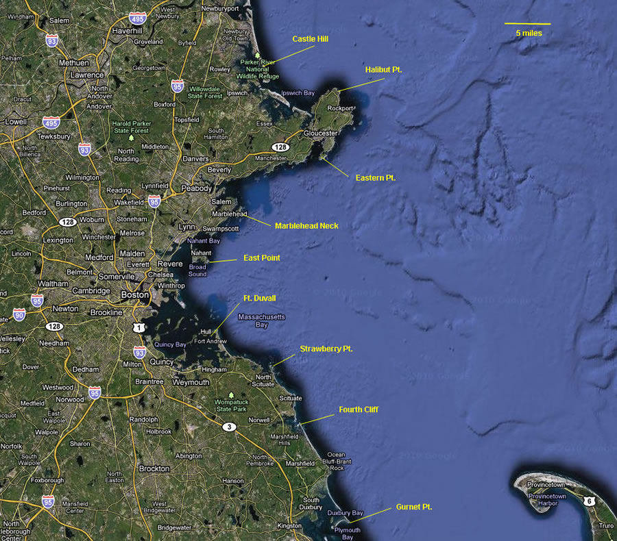
By WW2, coast defense artillery was more powerful still, and the guns and fire control capabilities of the Boston defenses grew apace. Slide 4 shows the northern-most fire control position during WW2 (Castle Hill) and the southern-most (Gurnet Pt.), separated by a distance of some 55 miles. During WW2, Boston's biggest guns were the 16-inch batteries at East Point (Nahant) and Ft. Duvall (Hull), which could cover the full 55-mile line of defense. (NOTE: The two northern-most fire control positions of the Boston defenses were shared with the defenses of Portsmouth, NH, and the 16-inch guns of Portsmouth's Btty Seaman could also reach down the coast to Cape Ann, past Halibut Pt.)
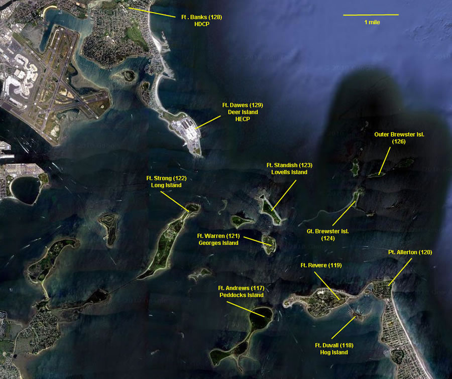
Slide 5 matches up the harbor forts with the islands upon which most of them were located. It also ponts out the inland Harbor Defense Command Post (HDCP) at Ft. Banks ( the former mortar fort in Winthrop) and the Harbor Entry Control Point (HECP) at Ft. Dawes on Deer Island. A third 16-inch gun battery was planned and contstructed at Ft. Dawes (Deer Island) and had its gun tubes delivered, but these guns were never mounted, since by that time, the possibility of a seaborne attack on Boston seemed remote.